Foothill Flyers Mountain Trail Runs
Last update August 14, 2021
Brown Mountain Loops
These three trail runs start and finish from the west end of Altadena Drive (A) in Altadena. From the 210 take the Lake Ave off ramp and go north about 2.7 miles. Turn left at Altadena Dr and go about 2 miles to the end. Park on the street. Trail starts at the end of the street and goes down into the Arroyo Seco. Click on Map for location
Click on either of the trail maps to down load for printing.
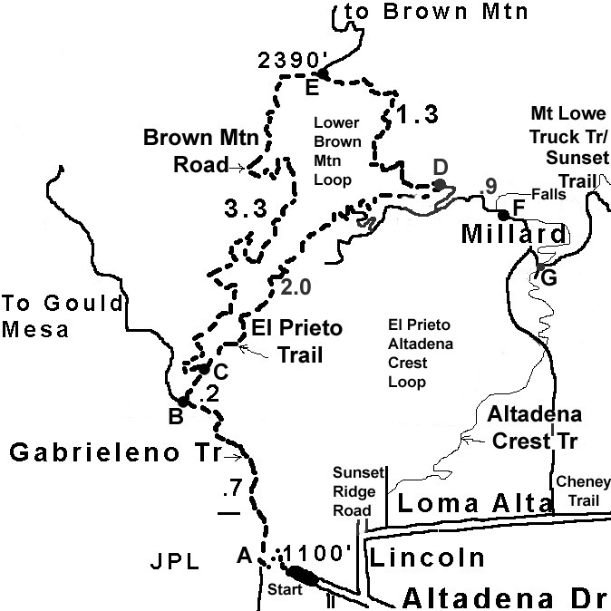 The Lower Brown Mountain / El Prieto Loop can be run clockwise or counter-clockwise depending if you prefer running down hill on a single track or dirt road. As you go up the Arroyo, watch for a dirt road curving off to the right with the Brown Mtn Sign (B).The split for the loop is a hard left hairpin turn on Brown Mountain Rd at the bottom junction with the El Prieto Trail (C). If you run it clock-wise, go up the dirt road and you will find a point where it levels off at a small saddle with a junction (E). Turn right and go down the lower dirt road. Watch for the El Prieto single track trail junction on your right a little after a mile (D). This single track goes down a valley with a number of stream crossings. At the bottom you will come back to the dirt road you took up. The El Prieto Trail is part of the Angels Crest 100 Mile Trail run.
El Prieto/Altadena Crest Trail Loop - An alternative to the Lower BrownMtn Loop is to go up the El Prieto trail and at the junction with Brown Mountain Road (D) turn right and go .9 miles to Millard Campground (F). There is Millard Falls trail at the west end of the campground that can be reached after a half mile up the canyon. Continue up on a single track on the east side of the campground to the top of the ridge, cross the Mt. Lowe Truck Road by the water trough (G), and go down the Altadena Crest trail to Loma Alta for a different total loop of about 7.1 miles back to the cars at the end of Altadena Dr.
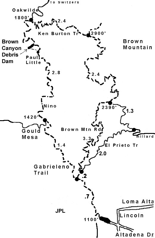 The Brown Canyon Debris Dam run up the Arroyo Seco on the Gabrieleno Trail is a nice walk/jog of about 8.5 miles round trip. The Station Fire totally destroyed the bridges and what was once a fire road is now a single track trail. Having said all that, this now might become one of the Weekend Warriors favorite trails. It is a lot more runnable than some that we do and the shade and water crossings make it idea for those hot summer days. There is an off shoot trail to the left after the Paul Little camp ground that will take you to the base of the dam. If you stay on the trail to the right it climbs up over dam and goes to the Oakwilde camp ground.
The Upper Brown Mountain Loop goes the same way as the first half of the Lower Brown Mountain / El Prieto Loop, but at the dirt road split, you turn north and go up to the end of the road. The Ken Burton Trail is a single track that goes to the west from the Brown Mountain dirt road dead end and drops down with lots of switchbacks into the Arroyo to cross the river just above Oakwilde camp. This trail got destroyed during the Station Fire and may not have been rebuilt yet. If so, return the way you came.
There is no water available past the Ranger station on the Gabrielino Trail just north of the junction with the Brown Mountain dirt road. This is a long loop so bring lots of fluid.
Back to: Run Routes & Maps - Foothill Flyers home page - Weekend Warriors