Julie Miller recounts:
At 5:06 a.m. Monday, August 2, 2010, Foothill Flyers Tom and Mary Ann O'Hara, Nancy Gilmore, accompanied by her son Randy and her grandson Michael, Robert and Maria Vangilder, Denh Vuong, Leslie Hallimore, and Julie and Ken Miller set out in the dark from the Curry Campground at Yosemite National Park to climb the iconic Half Dome.
Half Dome is all about elevation and illumination. Rushing waterfalls, wooded trails, endless switchbacks, and the final climb up the dome using cables, make this hike unforgettable.
After hiking seventeen miles round trip, climbing to 8844 feet altitude with 5,000 feet of elevation gain, the Flyers were happily drinking delicious iced lemonade at the Happy Isle snack shop and recounting the adventure of a lifetime.
The Hike
Ideally located near the start of the trail, Curry Campground has tent cabins with single and double beds, linens, blankets, safes and bear proof boxes. Near by there are clean bathrooms, showers and a swimming pool. Curry Pavillion serves pizza, a buffet, burgers, tacos, ice cream, and even has a coffee shop
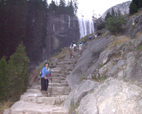
Crossing the Happy Isle bridge in the dark just after 5 am, we started out by hiking the High Sierra trail parallel to Vernal Fall, to reach the Mist Trail.
The Mist trail is 1.4 miles, 1400 ft climb and is comprised of 700 steps gleaming with the spray from Nevada Fall. After 2000 feet of climbing from the start, the Flyers reached Little Yosemite Valley, where the trail eases to a delightful walk in the park through the woods and flowers as we hiked around to the subdome. The subdome consists of about 800 granite steps with no handrails. This is like doing Bailey Canyon at 8000 feet.
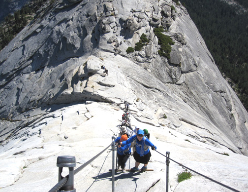
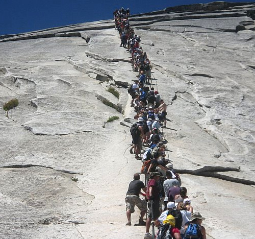
The infamous cables take the climbers up the last 425 feet of vertical rise to the top of Half Dome after the sub dome. The steel cables resemble two banisters. The Flyers donned their gloves to pull themselves up the 45 degree incline of the granite.
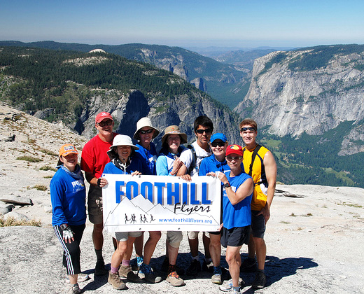
Atop Half Dome at 11 a.m., the Flyers celebrated Robert Vangilder's birthday, with a small chocolate cake. Robert carried the Flyer banner for a photo and Maria hooped. (No, not whooped, she actually hooped, with a portable hula hoop that she hauled all the way to the top strapped to her camelback). Julie and Leslie admired the views from "The Visor", a small overhanging ledge a dizzying 4800 feet above the floor of the Valley.
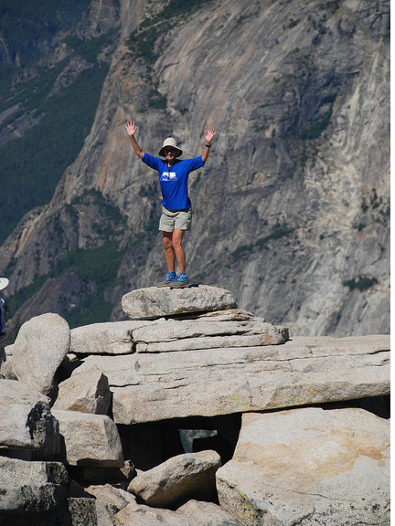
When you are on the top of Half Dome all the little problems that you brought with you are just that. You reach the top, the view is spectacular, and all your cares are forgotten. Against a brilliant Flyer blue sky, cute, and well-fed marmots came out of their rocky dens to sun and try for a handout.
We left at noon, and found that the base cables - which were almost empty when we climbed up - were now congested with a line of hikers waiting to assend and reach the top of Half Dome. As they waited in line for their chance, they were eager to hear what it was like at the top.
We returned the way we came except that on the way back, we took the John Muir trail instead of the Mist trail at the junction after Little Yosemite Valley. This is a delightful area that crosses water several times. It goes past the Panorama cliff, which continually drips water giving it a rainforest appearance.
Logistics and tips
Read Rick Deutsch's excellent book, One Best Hike: Yosemite's Half Dome, which is available at REI. Curry Camp reservations can be made on the website. Call 1-801-559-4892 or go to the Curry Village web site for more information and to make reservations. Reserve early as all accommodations in the Valley sell out.
When to go? Check when the cables are up. The cables are usually up the weekend before Memorial Day in May to early June, and taken down in October. A permit is required to use the cables on Half Dome on Friday, Saturday and Sunday, and have a limit of 400. The permits cost $1.50. See: permits. The other weekdays are free and we found that Monday was the most crowded day. We did right to start early at 5 a.m. to avoid most of the crowd coming up as we were coming down.
Food: Bring a lock for your bear box to keep people out. Food options abound, including Curry Pizza, Curry Buffet, Curry Coffee and Ice Cream. Other than what you intend to eat on the hike, you really don't need to bring food. Any food, drinks, coolers, lotions, tooth paste, etc., that bears can smell and be attracted to, must be put in your bear box. There is a free shuttle or you can drive to the nearby Yosemite Lodge and eat at the Mountain View Room or Food Court for more variety.
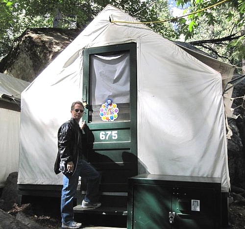
Camp Curry tent cabins sleep 3. Note the bear box bottom right.
Water - I brought 86 oz of water, but I could have used more. Consider bringing at least 100 oz, and chemical tablets, or a purifier or steripen, so you can take water from the Merced River. We were out for about 11 hours, and especially at altitude, you need to drink a lot of fluid.
Other Activites: This is Yosemite National Park! I recommend hiking up Yosemite Falls (next to the Yosemite Lodge) for the spectacular view. Another scenic hike is the Panorama trail. You can take a shuttle from the Awhanee or Yosemite Lodge to the top of the Panorama trail from Yosemite Lodge so that you only need to hike down. Or rent a raft at Curry Village and take a 3 mile raft trip down the Merced for $26.00 per person. A shuttle will bring you, and the raft back.
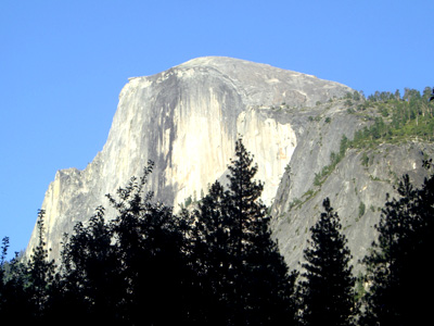 This hike has to be in most California trail runners bucket list just for the unique beauty of this area. Yosemite Valley was formed by a glacier that wore off half of the dome and left it with a shear drop on one side. The other side is accessable but the trail is challenging. The distance and elevation gain are similar to hiking Mt. Baldy or Mt. Wilson - both good training hike/runs for Half Dome - but the differences are the many rock steps and narrowness of the trail in places. And then there are the cables for the final assent to the top. The National Park Service has a great web site with lots of information, maps, directions, etc., if you plan to make the trip to Yosemite Valley and Half Dome. Photo right is Half Dome - 8844 ft - viewed from Camp Curry 2 miles away as the crow flys.