Foothill Flyers Mountain Trail Runs
Last update Nov 1, 2008
Hastings Peak Loop
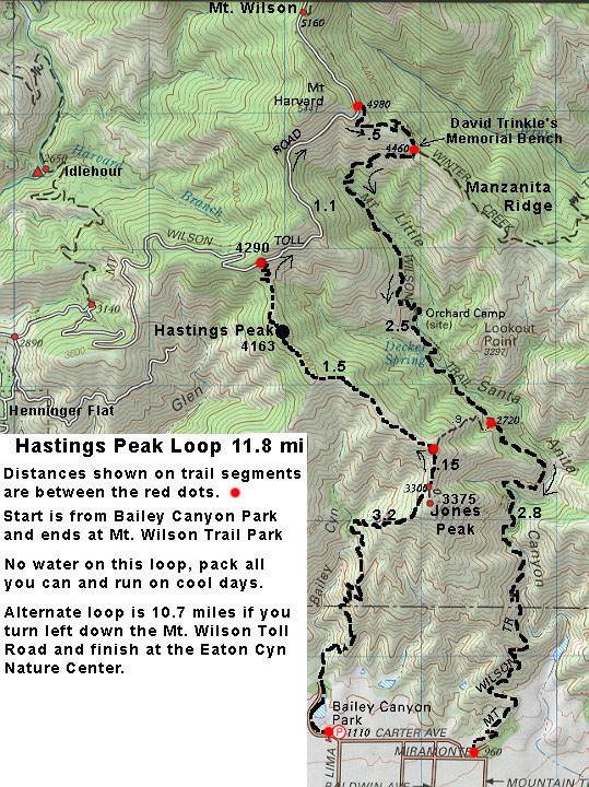 This is a tough loop of 11.8 miles, 4500 ft climb, no water resupply, but fantastic views over varying terrain. It is a good training run for a trail ultra. This loop is best done starting early in the cooler months and carrying as much water as you can.
The Hastings Ridge section is 1.5 miles long and goes from just above Jones Peak Saddle to the Mt. Wilson Toll Road - look for the sign that points to Hastings Peak to the left and up or straight and down to the Mt. Wilson Trail. Hastings Peak is about 1 mile up on single track that passes through some sandy and grassy saddles with flora that in not typically found in Little Santa Anita or Bailey Canyon. Even if you elect not to do the whole loop, an out and back 2 mile loop from the saddle to the peak is well worth it. The views of the LA basin are spactacular too.
If you plan to do the loop, the final climb up to the Mt. Wilson Toll Road is steep. Once at the Toll Road you can turn right to go up 1.1 miles to the junction with the Upper Winter Creek Trail and do the full 11.8 mile loop as shown on the map, or turn left and go down the Toll Road 5.7 miles to the Eaton Canyon Nature Center via Henninger Flat.
The highpoint at 4460 ft msl is at the junction of the Toll Road and the Upper Winter Creek trail just below Mt. Harvard. But if you continue up the Toll Road there is a single track about a half mile up and on the right that will take you to the Mt. Wilson parking lot after another half mile. There is a drinking fountain at the north end of the parking lot.
Turning right down Upper Winter Creek you will drop down 500 ft in about a half mile to the junction with Mt. Wilson Trail. At this junction is a bench that is a good place to stop and eat what ever lunch or snack you have brought. The view is great and for at least until noon, there is some shade from the trees.
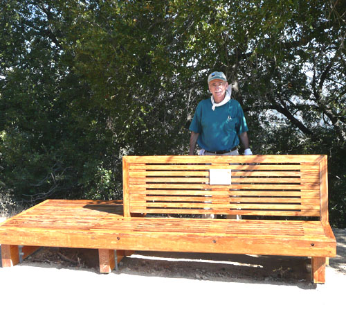
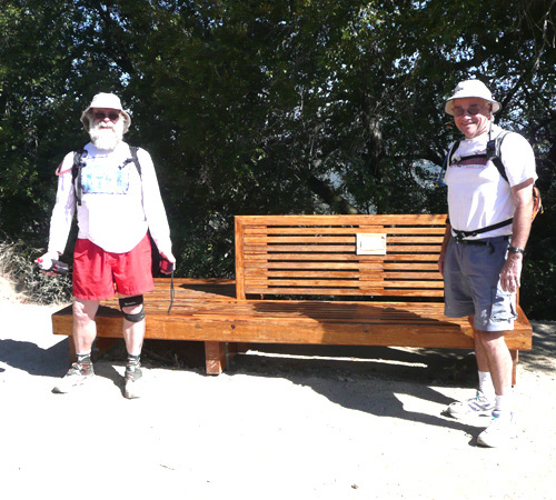
Left: This bench was built by Hal Chiasson and friends in memory of David Trinkle who slipped off the Mt. Wilson Trail to his death in 2000 - click on the link and scroll down to the Trail Re-route paragraph. Right: Roger Brown and Tom O'Hara recruited by Hal to help him sand and refinish the bench before running back down to explore the Hastings Peak Trail.
If you left a car at the Mt. Wilson Trail Park on Mira Monte at Mountain Trail, you are done. If not, you have about .9 mile to go West on Mira Monte then turn right on Carter to get back to Bailey Canyon Park.
Back to:
Run Routes & Maps
Bailey Canyon Trail run
Henninger Flat Trail run
Foothill Flyers home page
Weekend Warriors