Foothill Flyers - Road Trips
Last update October 12, 2023
Return to: Race Reviews
- Run Routes and Maps
- Foothill Flyers Home Page
- Weekend Warriors
Climb Mt. Whitney
 Julie Miller writes:
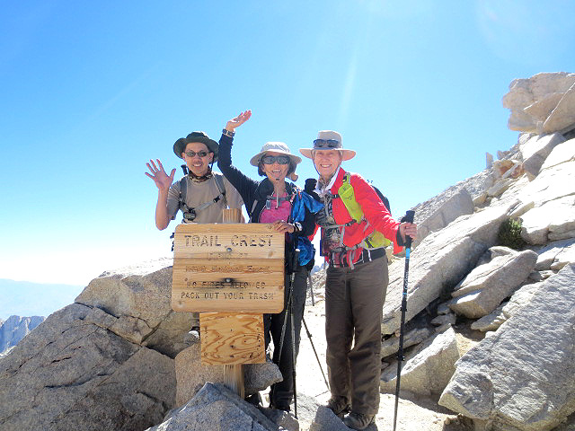
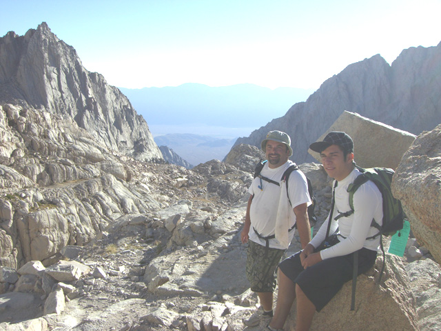
On Thursday, August 28, 2014 , I made it to the top of Mt. Whitney with Karen Johnson and Randy Wong. We were blessed with the most beautiful sunny alpine weather. We stayed Monday and Tuesday night right next to a waterfall at Whitney Portal (about 8,300' elev.) to acclimate, and then entered Whitney Zone on Wednesday. We camped the lovely Outpost camp (over 10,365') to acclimate some more. The big day -- Thursday, August 28 - climbed Whitney. We were so so happy at Trail Crest (13,800'elev.) that no one was altitude sick -- we were dancing around. Too many stories to tell. The top was glorious. We stayed there an hour -- Randy was loving it and wanted to stay up there longer, while Karen and I headed back to "base camp" -- Outpost Camp. We exited Friday, tired but happy. No bears, but did you know they have the cutest marmots on top of Whitney? They look like big guinea pigs, and they whistled at us!
August 2007
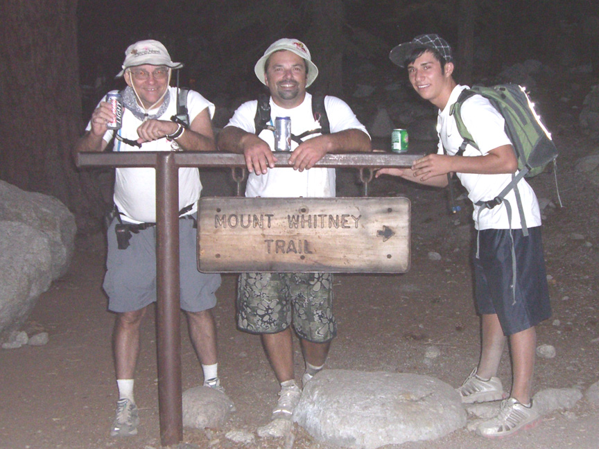
I don't know where my son Rick, age 41, got the idea he wanted to climb Mt. Whitney, but he mentioned it last Thanksgiving. I stopped at Trail Crest during an attempt in the 70's due to altitude sickness and just out of shape. I had always wanted to complete it, and now at age 65, I thought I had better do it while I can. Also maybe it was a goal to shoot for that would help Rick get back in shape. It seems we both shot up in weight 30-50 pounds in the first years of marriage, and he helped me when he was 18 by training and pacing me to my PR at the Honolulu and Catalina Marathons. So I said I would do it with him to pay him back. I was also surprised and glad when my grandson Tommy, age 14, also said he would do it with us and help his dad - may be the beginning of a tradition.
Picking the brains of some of the Foothill Flyers club members who have done the Mt. Whitney main trail, I found that you need to apply for a permit that is given out lottery style in February even if you want to attempt it in one day and not overnight camp at various altitudes as most people do. Basically you apply for the dates you want to hike in order of preference and they notify you in April as to which date you got. There is a good USFS web site with all the info. After the lottery, the web site will list how many slots are still available on each day. Most weekends will be full, but mid week will typically have permits available until the last minute and is worth checking.
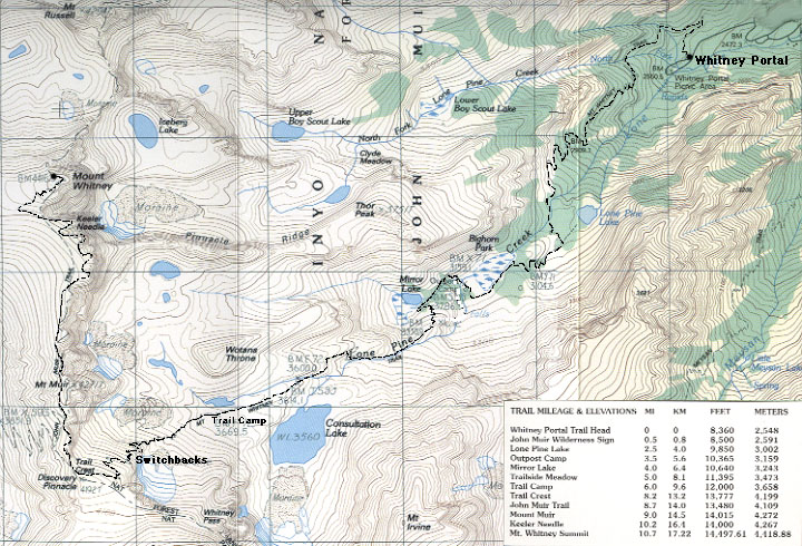
The trail starts at the Whitney Portal about 12 miles west of Lone Pine CA and Hwy 395 - 8360 ft msl, and climbs to the highest point in the contiguous USA, 14,505 ft msl after 11 miles. I would compare this trek to a trail 50K in which minimum endurance training would be to work up to and do three 4 hour+ hikes shooting for a 20-30 minutes per mile pace and spaced 2 weeks apart. However, the difference here is we needed to do the hikes at altitude and carry all our food and water. I picked Mt. Wilson, Mt. Baldy and Mt. Baden-Powell, and each had some similarity to the Whitney main trail.
Besides the physical training, it would be a discovery for my son and grandson as to what kind of shape they were in, but more important, how much water and food they would have to carry.
I brought a scale to weighed them before and after each hike which was an eye opener. My son had a hard time on Baldy and found that he had lost 5 lbs which equates to 80 oz of fluid that he should have drunk over the time period. My grandson on the other hand, was like a mountain goat bouncing around on the trail and hardly lost any fluid.
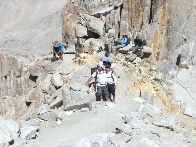
 On Wednesday August 22 we drove up to Lone Pine and checked into the Dow Villa Motel - did you know John Wayne stayed in room 20 there when he made his western movies? Next morning we left at 3:30 AM and started up the trail at 4:10 AM with flashlights in the cool morning air. Good easy trail to Lone Pine Lake so we had no problem in the dark and we were doing 30 minute miles... but not for long. At Mirror Lake, 4 miles in and 10,640 ft, we switched off our lights and were feeling the altitude. From there the trail gets tougher with some stone steps up to 1.5 ft high.
Every half hour we would drink a few good gulps of water and every hour stop for a few minutes to eat at least 200 calories of trail mix, sport bar, Blox, etc. On the hour I also checked in with Mary Ann back at the hotel on the ham radio walkie-talkie to let her know how it was going for us - the Lone Pine 146.760 repeater had good coverage for us on the trail most of the time, but Mary Ann had to find a magic spot by the Dow Villa Motel pool.
I think we may have overcompensated and drank too much given our prior training run experience and the 100 degree mid day temperature in Lone Pine, as Rick and I were out of our 130 oz of water in our Camelbacks and bottle by the time we reached the Lake at Trail Camp and the start of the 100 switchbacks at 8:30 and just 6 miles in but at 12,000 ft. Thanks to a tip from Ultra Trail runner and Badwater finisher Bill Dickey, the best water to refill can be found between the 15 to 20th switchback up from Trail Camp. It is from an ice cold snow melt spring with the least possibility of contamination. However we used our KlearWater fluid mixed in just in case. I credit the pack it in, pack it out and limited permit system for the trail and lakes being as clean and clear as they are today compared to what I remember when I was on this trail back in the early 70's. When you pick up your permit in Lone Pine the day before, they even give you a "poo bag" that if you use it, you gotta pack it out... Best to, shall we say, do your best to clear the chute before you start.
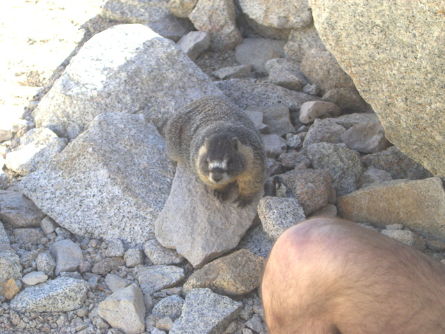
One of the friendly marmots that hang out at Trail Camp knowing they are too cute to resist giving them a bit of your food.
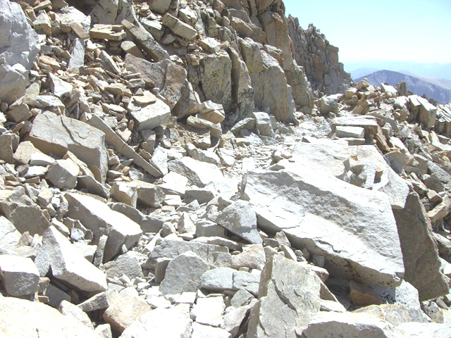
The next 5 miles are exciting with the toughest part of the trail to the top and in full sun. We got lucky with the weather on this day. It is the radiation you feel most, but the temperature was a comfortable 70 with 10-15 mph wind. Sunscreen is a must. Trail Camp is a good place to check for clouds and possibility of lighning strikes before starting up the switchbacks. I don't know if the dreaded switchback section is 99 or 120 turns but the trail is all on a shale slide for over 2 miles and a rise of over 1600 ft. Anyone who has done Whitney will tell you that the switchbacks are tough and they lost count after a few dozen on the way up.
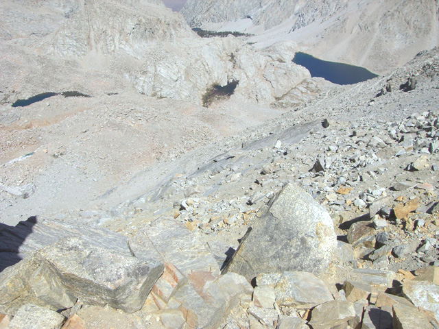
Looking down the 100 switchbacks to Trail Camp and Consultation Lake. Looks tricky from the photos, but the trail is actually a well maintained single track in the summer and easily hiked.
At this point I think we were down to 1 mph and stopping to catch our breath every 5-10 switchbacks. Finally at the top at Trail Crest - 13,600 ft and 8.2 miles in - you suddenly cross a narrow ridge and can see beautiful canyons and lakes on the Sequoia side to the west and toward Lone Pine on the east thousands of feet below. It is unbelievable and one of the most spectacular vistas on this trail.
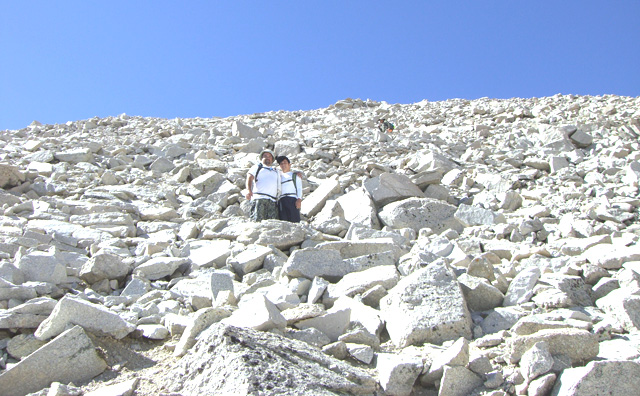
From this point the trail joins the John Muir trail and for the next few miles you really need to concentrate on each footfall as the trail is mostly all loose rocks waiting to tweak an ankle if you are not careful. Also, it is best to come to a complete stop to take a look around, drink or eat as the altitude and drop off plays tricks with your balance. We had no trouble with altitude sickness thanks to the 12 hr Sudafed we took at the hotel that morning and staying well hydrated. Also, take another look for cloud build up and talk to others about the possible lightning. Once on the John Muir trail, you are very exposed.
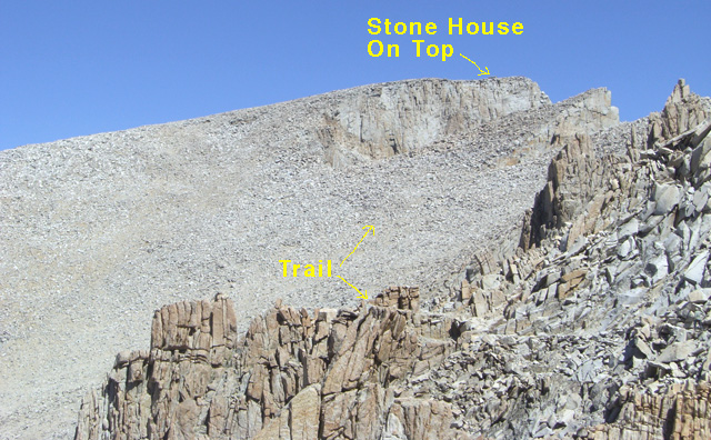
The first view of the Stone House on top is about a mile away as you turn a corner on a very rocky trail. It is only a mile, but at this altitude it took almost an hour to get there - no Sherpas with O2.
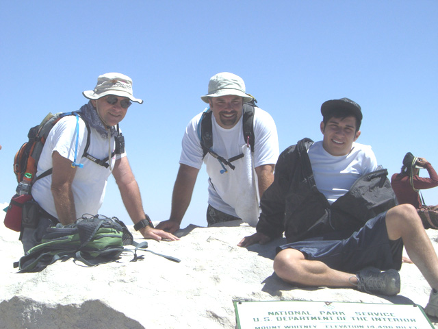
We finally make it to the top in 9 hours 45 minutes and sign the book at the stone cabin. What a sight for 360 degrees! Again, we luck out with the weather as there are no clouds, which often build up in the afternoon and zap the cabin with lightning - another good reason to start no later than 4 AM at the Portals.
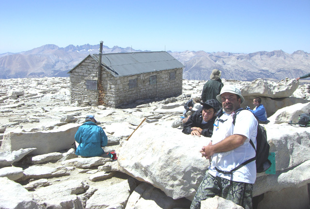
Contrary to what you may have seen on the internet, this is not a Starbucks atop Mt. Whitney.
After a half hour on top to rest, eat, take pix, and schmooze with other hikers who have made it, we take 5:30 to come down reaching the Portals just after sunset and a family adventure we will never forget.
A proud grandpa, Tom O'Hara
August 23, 2007